Gressa Castle
 |
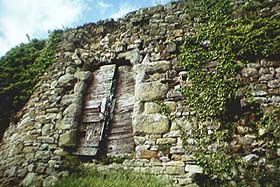 |
| The internal enclosure with the keep at its center. | The gate of the second walled circuit. |
The castle of Gressa rise to about five kilometers from Bibbiena, in the heart of the Casentino. From the road that leads to the Franciscans sanctuary of the Verna we find on the left a deviation, signalled, that conducts on a paved road that ends under the castle.
Click here for a map of the castle
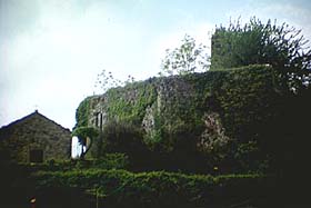
The castle of Gressa rises on a knoll of 585 meters bathed by the homonym stream in the valley of the river Archiano, at little distance from the city of Bibbiena. From this position is possible to dominate the whole underlying valley. From the 1078 Gressa is named on some documents as 'castrum', even if the first certain sources on the conformation of the castle or on whose were its owners are only of the 13th century. From the chronicles of the time the castle is pointed out as ownership of the bishops of Arezzo, that used it as fortified summer residence. Due to its geographical position, surrounded from Episcopalian castles as Bibbiena, Marciano, Gello and from the Monasteries of Camaldoli and Prataglia, we can deduce that also its foundation is attributable to the aretine bishops.
 |
|
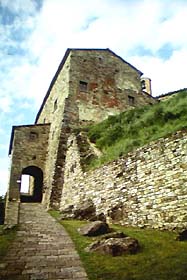
The Bishop Palace with the gate of the outer walled enclosure. |
From chronicles of the 14th century we learn that the castle was besieged and conquered by the Florentines in 1259. Afterwards the aretine bishops taken back the fortification and in 1356 there was another Florentine, failed at this time, attack. It also seems that Gressa has been the last of the castles of the Casentino to remain in possession of the bishops.
The castle, today with large parts in downfall and with urgent need of restoration, is constituted by a first surrounding wall with irregular polygonal plant, of which only few lines remain, gifted of a beautiful gate in correspondence of the Bishop's Palace, in good static conditions thanks to a recent restoration. This entourage encircles the layers of the relief. The second wall circuit is concentric to the first one and tightens the most elevated zone of the hill. Also this enclosure has irregular form, assimilable to an octagonal polygon, due to the adaptation of the masonry to the ground. In some lines the walls reaches five meters of high. The gate of access to the core of the fortification was accessible through timber staircases today disappeared. To the inside rise, on the most elevated point, a tower with rectangular plant, developed on three plans, that had functions either of residence how military. The whole complex is built in sandstone and calcareous stone of irregular form, to the exception of the angles, gifted of big square blocks.
Between the two walls circuit are preserved two cisterns for the supply of water, whose inside masonry has covered from an impermeable plaster, a church and two hamlets, whose structure has been altered by the recent restorations.
| View the castle Map |
| Back to Homepage |
| Back to Castles Index |